Aircraft Navigation Testing
Navigation is a critical piece to aircraft operations. There are several subsystems that contribute to a pilot’s ability to correctly navigate an aircraft. Let’s look at some of the systems and how they are tested:
VOR (VHF Omni-Directional Range):
-
-
-
- VOR is a critical component used for navigation.
- It provides azimuth information (bearing) to and from ground-based VOR stations.
- Aircraft equipment includes:
- VOR antenna: Receives VOR signals.
- VOR frequency selector: Allows pilots to tune in to specific VOR frequencies.
- Course Deviation Indicator (CDI) or Horizontal Situation Indicator (HSI): Displays course information based on VOR signals.
-
-


Distance Measuring Equipment (DME):
-
-
- DME provides accurate distance measurement between the aircraft and a ground station.
- It calculates distance based on the time it takes for radio signals to travel.
- Used for precise distance measurements during approaches and en-route segments.
-
Instrument Landing Systems (ILS):
-
-
-
- ILS guides aircraft during approach and landing.
- Consists of localizer (horizontal guidance) and glide slope (vertical guidance) components.
- Pilots follow ILS signals to align with the runway centerline and descend at the correct angle.
-
-


Marker Beacons:
-
-
- Used in conjunction with ILS to provide pilots with a
means to determine position along and established
route, particularly during approaches to runways. - Outer Marker (OM): 4 to 7 nautical miles before runway
threshold. - Middle Marker (MM): 0.5 to 0.8 nautical miles before
runway threshold. - Inner Marker (IM): Located at runway threshold
- Used in conjunction with ILS to provide pilots with a
-
GPS (Global Positioning System)
-
-
-
- GPS provides accurate position information using signals from satellites.
- Aircraft GPS receivers calculate latitude, longitude, altitude, and groundspeed.
- GPS is widely used for both en-route and precision approaches.
-
-


Functional Testing:
-
-
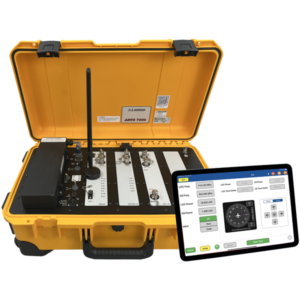
- Regularly testing the radio navigation systems of an aircraft is essential to its performance.
- Test systems like the ARTS-7000 can transmit radio signals to the aircraft under test that simulate ground stations and runways.
- These tests will ensure aircraft navigation systems are performing to spec.
-
Remember that these components work together to ensure safe and efficient navigation for aircraft during all phases of flight.
YOU MAY ALSO LIKE
-
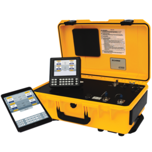
MODEL 6600-NG
Read moreRVSM pitot-static tester for AoA / AoS / SmartProbe applications (3-channel)